Class 10 Geography Chapter 1 Resources and Development covers all Extra Questions and Answers of various types i.e. from short questions to long questions, related to the topic so as to help the students with their preparation by helping them do an in-depth study of the topic.
The chapter begins with an introduction to what resources are and its types based on varied characteristics. The following sections discuss the concept of resource development and resource planning. This is followed by a discussion on land resources and their utilisation. The topics of land degradation and conservation measures are discussed. The next discussion deals with soil as a resource. The chapter ends with a discussion on soil conservation.
Class 10 Geography Chapter 1 Extra Questions are Answered in detail by our team of experts which includes teachers and professionals. These solutions have been compiled in an easy to understand manner, keeping in mind, the perspective of strong, and weak students. We are providing NCERT Solutions for Class 10 all subjects which can be accessed by clicking here.
Class 10 Geography Chapter 1 Extra Questions and Answers – Very Short Type Questions: [1-2 marks]
Ques.1: Define resource.
Ans.1: The things available in our environment that can be used to satisfy our needs is a resource. A resource is technologically accessible, economically feasible and culturally acceptable.
Ques.2: The process of transformation of things available in our environment involves an interactive relation between _______, _______ & ________.
Ans.2: nature, technology and institutions
Ques.3: Resources area function of ___________.
Ans.3: human activities
Ques.4: Resources are a function of human activities. Explain.
Ans.4: As humans modify and use the resources depending on their needs, resources become a function of human activities.
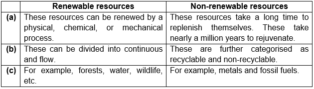
Ques.5: What are renewable resources divided into?
Ans.5: Renewable resources can be divided into continuous and flow resources.
Ques.6: Give the subcategories of non-renewable resources.
Ans.6: Non-renewable resources are divided into recyclable and non-recyclable.
Ques.7: Write short notes on sustainable development.
Ans.7: Sustainable development can be defined as a form of development which must take place without damaging the environment. The needs of the present generation must be fulfilled without compromising the needs of future generations.
Ques.8: Why are the other than the current fallow lands cultivated once or twice in two-three years?
Ans.8: The other than the current fallow lands are cultivated only once or twice in two-three years because either the land quality Is poor or the cost of cultivation over this land is very high.
Ques.9: Define gross cropped area.
Ans.9: Gross cropped area can be defined as the net sown area plus the area sown more than once in an agricultural year.
Ques.10: On what basis are the soils classified in India?
Ans.10: The soils in India are classified based on soil formation, colour, thickness, texture, age, chemical and physical properties.
Ques.11: What are badlands and ravines?
Ans.11: The land unfit for any kind of cultivation is known as badland. These badlands in Chambal basin are known as ravines.
Class 10 Geography Chapter 1 Extra Questions and Answers – Short Answer Type Questions:2-4 Marks
Ques.1: On what different bases have the resources been classified?
Ans.1: The resources have been classified based on origin, exhaustibility, ownership and status of development. Based on origin, resources are classified as biotic and abiotic. The resources are classified as renewable and non-renewable resources. The resources are classified as individual, community, national and international based on ownership. Based on the status of development, resources are divided into potential, developed, stock and reserves.
Ques.2: Differentiate between renewable and non-renewable resources.
Ans.2:
Ques.3: Discuss the problems caused by the overexploitation of resources.
Ans.3: The problems caused by the overexploitation of resources are:
- Depletion of renewable and non-renewable resources.
- Accumulation of resources in the hands of a few powerful individuals. This has created a divide in the society of haves and have-nots.
- Overexploitation of resources has also caused various ecological problems like global warming, land degradation, environmental pollution and ozone layer depletion.
Ques.4: India has enormous diversity in the availability of resources. Discuss.
Ans.4: India is a country with diversity. Different regions in the country house different resources. Rich mineral and deposits are found in Jharkhand, Chhattisgarh and Madhya Pradesh. Abundant water resources are found in Arunachal Pradesh. The states of Gujarat Rajasthan are endowed with huge potential in wind and solar energy.
Ques.5: Mention the steps involved in resource planning.
Ans.5: The steps involved in resource planning are:
- Identification and inventory of resources across the country: The resources all over the country are surveyed and mapped and analysed on a qualitative and quantitative basis.
- To harness these resources, a planning structure is formed which consists of technology, skill and institutional set up required for the implementation of the resource development plan.
- These development plans are then matched with the plans of development at the national level.
Ques.6: For what different purposes is the land used for?
Ans.6: Land is used for the following purposes:
a) Forests
b) Land not available for cultivation
-
- The barren and wasteland
- Land put to non-agricultural uses
c) Other uncultivated lands (excluding fallow land)
- Permanent pastures and grazing land
- Land under miscellaneous tree crops groves (not included in the net sown area)
- Cultruable wasteland (left uncultivated for more than 5 agricultural years).
d) Fallow lands
- Current fallow (left without cultivation for one or less than one agricultural year)
- Other than current fallow (left uncultivated for the past 1 to 5 agricultural years).
e) Net sown area sown more than once in an agricultural year plus the net sown area is known as gross cropped area.
Ques.7: Define soil. Which factors are important for the formation of soil?
Ans.7: The topmost layer of the lithosphere. It is responsible for plant growth and supports living organisms. The important factors that contribute to the formation of soil are relief, parent rock, climate, vegetation and time. Natural factors like change in temperature, actions of running water, wind and glaciers, activities of decomposers etc. also contribute to the formation of soil.
Ques.8: Write short notes on the following:
a) Black soil
b) Red & yellow soil
c) Laterite soils
d) Arid soils
e) Forest soils
Ans.8:
a) Black soil: This is black and is also known as regur soil. These soils are the best suited for the cultivation of cotton. For the formation of black soil, climate and parent rock material are important factors. These have good water retention capacity and are extremely fine. The nutrients found in black soils are potash, calcium carbonate, lime and magnesium. These develop cracks in summers, which helps in aeration of the soil. Black soil is found in Deccan plateau, spread over the states of Maharashtra, Saurashtra, Malwa, Madhya Pradesh and Chhattisgarh and extend in the south-east direction along the Godavari and the Krishna valleys.
b) Red and Yellow soils: Red soils are formed by the crystalline igneous rocks. Their red colour is a result of high content in these soils. The yellow colour appears when it’s hydrated. These soils are found in Odisha, Chhattisgarh, southern parts of the middle Ganga plain and along the piedmont zone of the Western Ghats.
c) Laterite soil: Laterite word is derived from the Latin word ‘later’, meaning brick. This soil is formed due to intense leaching due to heavy rain. These soils are deep, acidic and are deficient in plant nutrients. These are found in the states of Maharashtra, Odisha, West Bengal and the Western Ghats. Crops supported by laterite soils include tea, coffee and cashew nut.
d) Arid soil: These soils have a sandy texture and are saline. Due to the high salt content in some areas, salt s obtained by evaporation. Arid soils lack humus and moisture. Their colour ranges from red to brown. Irrigation facilities have enabled cultivation in arid soils in Rajasthan.
e) Forest soil: These soils are found in the hilly and mountainous regions. These soils are loamy and silty in valleys and coarse in upper slopes. Denudation occurs in snow-covered areas and soils are acidic with low humus content in the Himalayan areas.
Ques.9: Which factors cause soil erosion?
Ans.9: Soil erosion is caused due to the following factors:
- Human activities like deforestation, mining, over-grazing etc. cause soil erosion.
- Natural forces like water, wind, glacier, etc. also cause soil erosion.
- Gully erosion takes place when water forms deep channels in the soil.
- Sheet erosion occurs when topsoil is washed away by water.
- Wrong ploughing techniques can form channels in the soil which facilitate the flow of water through them and cause erosion.
Class 10 Geography Chapter 1 Extra Questions and Answers – Long Answer Type Questions:4-6 Marks
Ques.1: How are the resources classified based on the status of development?
Ans.1: Based on the status of development, the resources are classified as:
- Potential resources: These are the resources that are yet to be explored and utilised. For example, the potential of wind and solar energy in Rajasthan and Gujarat is still underdeveloped.
- Developed resources: These resources have been developed to their fullest potential with the help of advancement in technology.
- Stock: These are the resources which are present in the environment, however, the humans do not possess adequate technology to harness these resources. For example, water is made up of hydrogen and oxygen and hydrogen is a rich source of energy. However, we do not possess the technical know-how to harness the energy from hydrogen.
- Reserves: These can be considered as a subset of stock resources. Though we possess the technology to utilise these resources, they have not yet been put to use. For example, rivers have a huge potential to meet a variety of demands. However, it is being used only to a limited extent.
Ques.2: How are resources classified based on ownership?
Ans.2: Based on ownership, the resources are classified as follows:
- Individual resources: These resources are owned privately by individuals. These can either be farmers who own a land allotted by the government against the revenue payment or people owning houses, plots, etc. in the urban areas. Other examples of private ownership include plantations, pasture lands, etc.
- Community-owned resources: These resources are accessible to all the members of a particular community. For example, village commons, public parks, playgrounds, picnic spots, etc.
- National resources: These resources are owned by the nation. A country possesses legal powers to acquire private lands for the public good. Mineral resources, water resources, land and wildlife within the national territory and the oceanic area within 12 nautical miles belongs to the nation.
- International resources: These resources open to all the nations of the world. However, no individual country has the right to harness these resources without the concurrence of the international institutions.
Ques.3: What are the different reasons for land degradation in India? How can land be conserved?
Ans.3: The reasons behind the land degradation in India are as follows:
- Mining activities cause land degradation. Firstly, forests are cleared for mining purposes. After the minerals are extracted, these sites are left unattended, leaving deep scars and holes in the earth. This is the case in the states of Jharkhand, Chhattisgarh, Madhya Pradesh and Odisha.
- Overgrazing of land has also emerged as a major problem which causes land degradation. This is the situation in Gujarat, Rajasthan, Madhya Pradesh and Maharashtra.
- Land degradation in the states of Punjab, Haryana and western Uttar Pradesh is caused by over-irrigation which increases salinity and alkalinity of the soils.
- Dust in the atmosphere is discharged by the grinding of limestone for the cement industry and calcite and soapstone for the ceramic industry. These particles later settle down on land.
- Untreated industrial effluents discharged in the water bodies also pollute and degrade the land.
To save the land from being degraded, afforestation and proper management of grazing can be adopted. Plant shelterbelts, controlled over-grazing, proper management of wastelands, check on mining activities and proper treatment and disposal of industrial wastes and effluents can help reduce and control land degradation.
Ques.4: Give a detailed account of alluvial soils in India.
Ans.4: Alluvial soils are the most widespread soils in India. These soils are very fertile. They contain potash, phosphoric acid and lime. Crops like sugarcane, paddy, wheat, and pulses are cultivated in alluvial soils. The regions with these soils are very densely populated and also cultivated intensely. These soils are deposited by the three important Himalayan river systems, the Indus, Ganga, and the Brahmaputra. These soils are found in parts of Rajasthan and Gujarat, in the deltas of Mahanadi, Godavari, Krishna and Kaveri. These soils contain sand, silt and clay in different proportions. In the upper reaches of the valleys, the soils are coarse. These are found in Duars, Chos and Terai. The alluvial soils are also divided based on their age. These are classified as Bangar (old alluvium) and khadar (new alluvium). Bangar is relatively coarser and contains kanker nodules. Khadar is fertile as compared to Bangar.
If you have any feedbacks on Resources and Development Class 10 Geography Chapter 1 Extra Questions and Answers please write us on comment box.